Not just Baarle: Belgium and its Border Madness
 © VisitBelgium.net
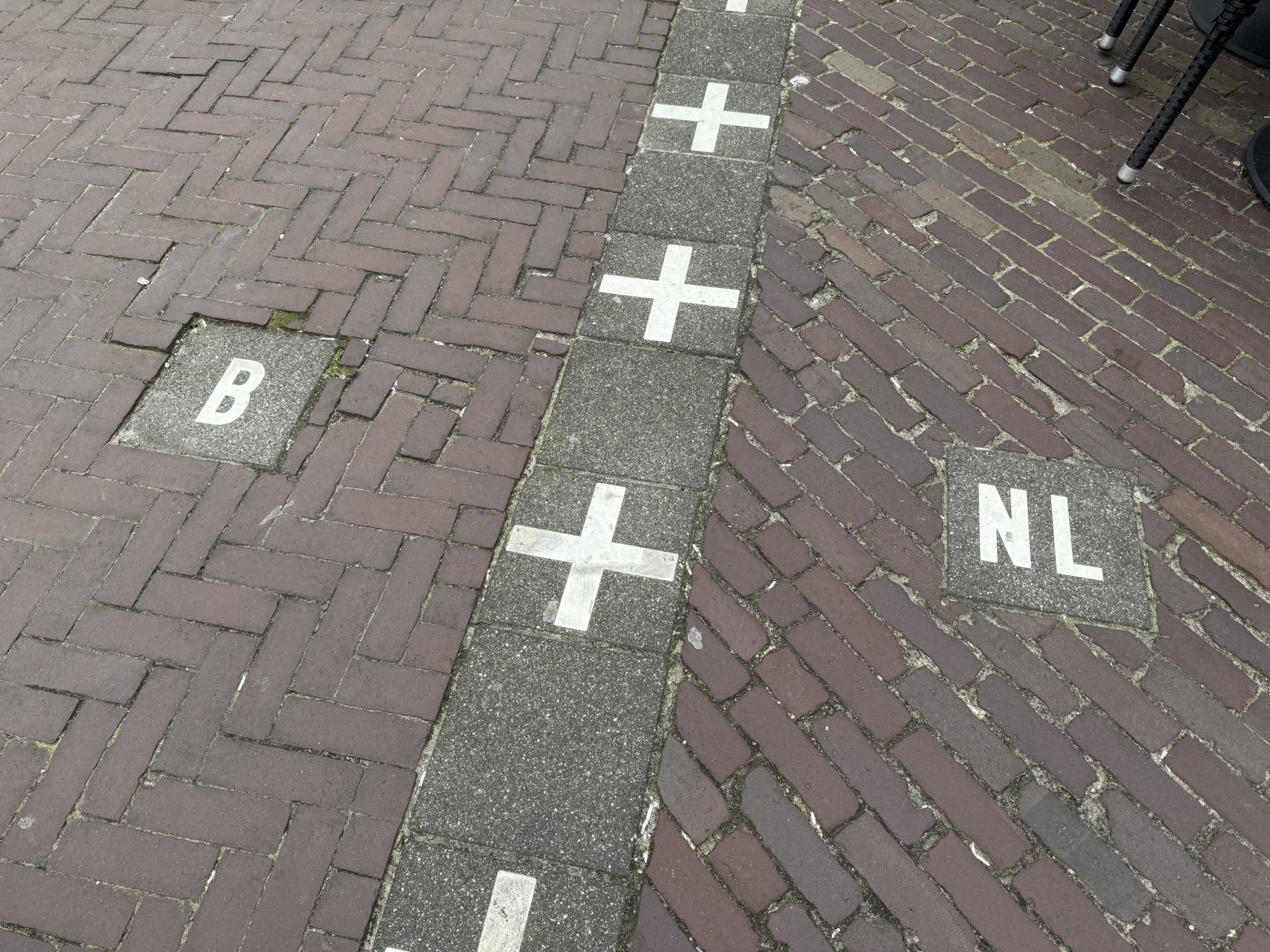
Europe is full of borders. Many of them have become invisible, others run along rivers or mountain ranges and seem almost logical. And then there is Belgium – a country where borders sometimes run through living rooms, states disappear, and gas stations determine which side you are on.
Anyone who engages with this will not find clear lines, but stories. Stories of compromises, coincidences, and surprisingly long-lasting historical decisions. Belgium is not a country you simply “pass through”. It is a country you understand in layers – and often only once you realize that you have just crossed a border without noticing.
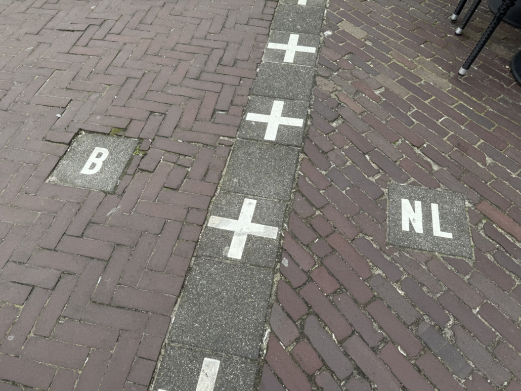
Baarle: where the front Door determines the State
In Baarle-Hertog and Baarle-Nassau, the idea of a border becomes almost absurd.
Here, it is not only drawn on maps but marked with small white crosses on streets. Right in the middle of the town lie 22 Belgian enclaves, completely surrounded by the Netherlands – and within them several Dutch counter-enclaves. The result is a geographical puzzle that is not to understand even on maps.
The cause of this apparent chaos goes far back into history. The complicated ownership structures date back to the Middle Ages, when parcels of land were divided between noble houses and local lords and reassigned again and again. Particularly influential were the Dukes of Brabant and the Lords of Breda, who controlled individual plots independently of one another. When modern nation states later emerged, these old property boundaries were largely adopted instead of simplified. The result is still visible today: a patchwork of enclaves that is less the product of deliberate planning than a preserved fragment of medieval land policy.
What is truly curious becomes apparent in everyday life. The national affiliation of a house depends on the location of its front door. There are buildings with two house numbers and two postal addresses. The border runs straight through a café: one table stands in Belgium, the next in the Netherlands. Or through a shop: even the position of the cash register matters.
Another aspect that can be observed particularly well in Baarle is economic differences. Prices and taxes differ noticeably between Belgium and the Netherlands – for example for food, alcohol, or tobacco. This leads to certain businesses deliberately setting up on the “cheaper” side. The border influences not only administration and daily life, but also very concretely where which business is worthwhile.
What is especially charming is how pragmatically the residents deal with it. When legal rules differ, usage is simply adjusted. During the COVID period, for example, different situations could suddenly arise within the same building depending on national regulations. Borders that seem absurd are interpreted creatively in everyday life.
Baarle is not a border town in the traditional sense. It is a place where the idea of a state is tested on a small scale – and functions surprisingly well.
Vennbahn: a Belgian Strip through Germany
A few hundred kilometers further southeast, a completely different form of border peculiarity appears. The so-called Vennbahn, once a railway line, belongs entirely to Belgium – even where it runs through Germany.
What initially sounds like a technical footnote has remarkable consequences. Along the route, small German territories emerge that are cut off from the rest of the country. Those who live there are in Germany, but surrounded by Belgian territory. In some cases, only narrow paths or roads lead back to “actual” Germany.
This situation dates back to the reorganization of Europe after the First World War, when Belgium gained control of the railway line – and thus of the entire strip of land on which it lay. That this would later become an international curiosity was likely unimaginable at the time.
Today, the Vennbahn is a popular cycling path that runs through landscapes where you cross the border several times without noticing. The political complexity remains invisible – making the contrast between historical significance and present-day ease all the greater.
Lille and Mouscron: a French metropolitan Area in Belgium
Lille is the third-largest metropolitan area in France, and it extends into Belgium. The national border between Lille and Mouscron (Belgium) almost completely disappears in everyday urban life.
The built environment merges seamlessly, streets lead from one country to the other without any noticeable interruption, and often only road signs or minimal differences in infrastructure reveal that you have just crossed a national border. It is a region where the concept of a border is increasingly dissolving.
At the same time, differences still exist – for example in tax systems, property prices, or administration. Those who look closely will notice that economic activities are often organized along this invisible line. Companies deliberately settle on one side or the other depending on advantages.
The region is part of the Eurometropolis Lille-Kortrijk-Tournai, one of the most visible examples of cross-border cooperation in Europe. The recurring discussions about extending the Lille metro fit this picture – even if concrete plans are still lacking.
The real peculiarity, however, lies in how unspectacular the border has become. It no longer feels like it.
Three-Country Point: when a fourth Country suddenly existed
At the three-country point near Aachen, Germany, Belgium, and the Netherlands meet today. A border stone marks this seemingly clear geographical point.
But the history of this place is anything but clear. In the 19th century, a small territory called Neutral Moresnet existed here, born out of a dispute over a zinc deposit. Neither Prussia nor the Netherlands could agree on ownership – so a neutral state was created.
This entity developed a remarkable life of its own. It had its own administrative structures, its own stamps, and even ambitious plans to turn the territory into an Esperanto state. For several decades, this inconspicuous place was in fact a four-country point – a geopolitical experiment in the middle of Europe.
Only after the First World War did Neutral Moresnet become part of Belgium. Today, hardly anything remains of this curious situation. That is precisely what makes the story all the more astonishing.
Incidentally, there is another geographical peculiarity here: the Vaalserberg is the highest point of the European Netherlands, which is extremely flat. However, the highest point of the summit actually belongs to Belgium.
Martelange: where the cheaper Side of the Street matters
In the small border town of Martelange, it becomes clear how directly borders can influence everyday life.
Here, the national border between Belgium and Luxembourg runs right through a street. What appears to be an inconspicuous line has noticeable consequences: on the Luxembourg side, ten gas stations line up one after another, while on the Belgian side there are mainly residential houses.
The reason lies in tax differences. Fuel is cheaper in Luxembourg, leading to a form of “border tourism”.
The curious thing is that the border is barely visible physically, yet extremely effective economically. A few meters determine prices, business models, and customer flows. It is a kind of economic laboratory in the open air – and at the same time one of the most tangible forms of border in Europe.
Bonus
Kusttram: a tram (almost) from the Netherlands to France
And then there is an almost poetic connection: the Belgian Kusttram.
It runs along the entire North Sea coast, from Knokke-Heist to De Panne. At around 67 kilometers, it is the longest tram line in the world.
Anyone who boards it can, in a way, traverse the country along its outer edge. The journey connects coastal towns, seaside resorts, and dune landscapes – drawing a line between two national borders.
Perhaps that is the most fitting metaphor for Belgium: a country defined not by its borders, but by what lies between them.
Language borders: invisible borders with great impact
Not all borders in Belgium run between states. Some of the most important lie within the country itself: the language borders between Flanders and Wallonia.
This line is clearly defined on the map, but often invisible on the ground. And yet it has enormous significance. It determines administration, education, media – and not infrequently political debates.
While international borders in Belgium are often barely noticeable, this internal border can be very present in everyday life. It is a reminder that borders exist not only geographically, but also culturally.
But it goes even further: the Brussels-Capital Region is officially bilingual, though about 80% francophone, and is surrounded by Flanders, while Wallonia is not far away. Brussels is not Flanders, yet it is the capital of Flanders.
Conclusion: a Country that shows how relative some Borders are
Belgium is not a country of clear lines. It is a country of transitions, historical coincidences, and compromises.
Here, borders run through houses and streets, disappear in everyday life, or exist only in history books. And it is precisely these contradictions that make the country so fascinating.
Anyone who travels through Belgium is not just moving through spaces, but through stories. And sometimes, a single step across an inconspicuous line is enough to realize how relative borders can be in certain places.
 © VisitBelgium.net
Leave a Reply
Want to join the discussion?Feel free to contribute!